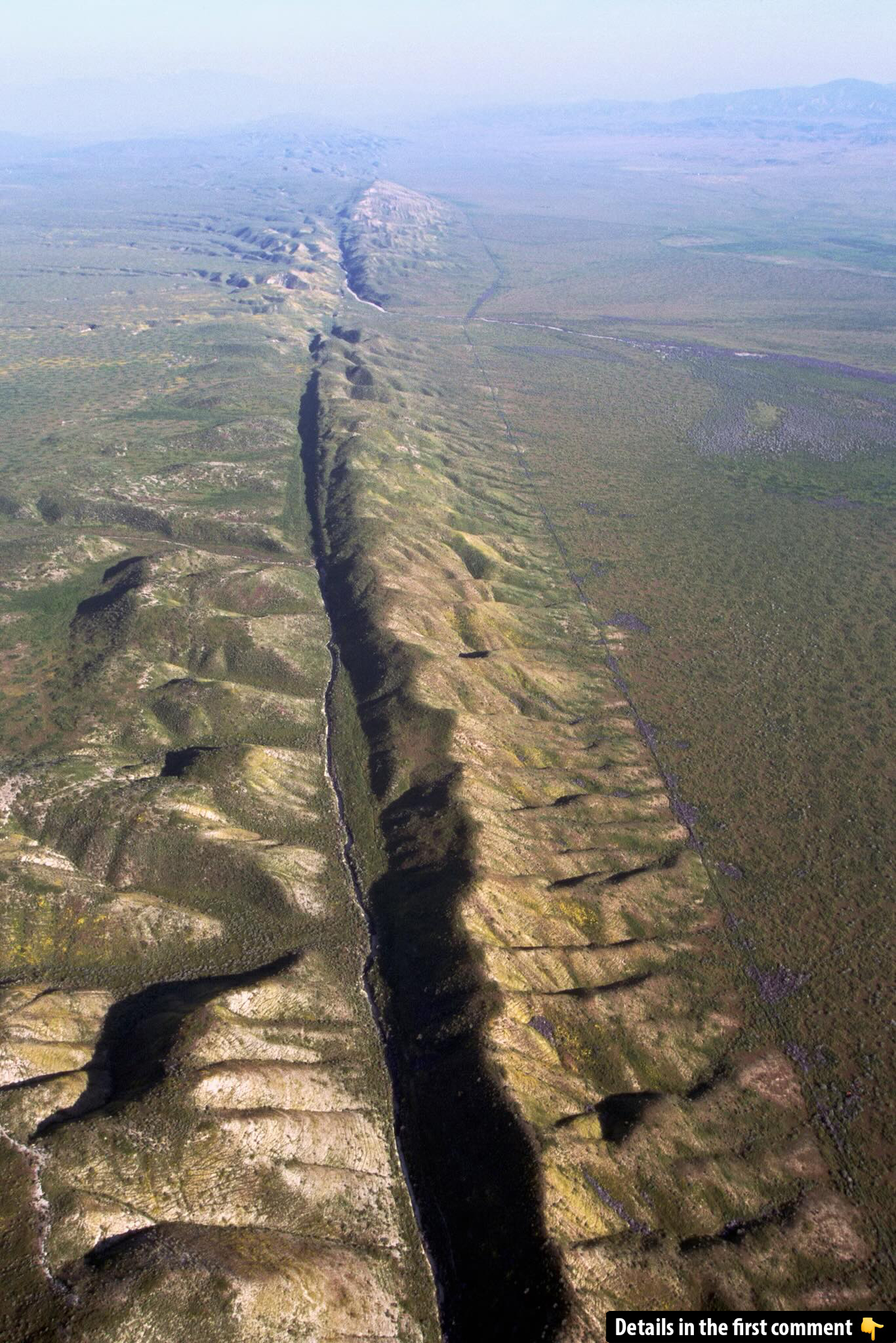
The San Andreas Fault, one of the most famous geological formations in the world, runs through the heart of California, dividing the state into two distinct regions. This massive fault has fascinated scientists, geologists, and the general public alike for centuries. It holds critical importance in the study of plate tectonics, and its ability to generate large, destructive earthquakes has made it a focal point for seismic hazard studies. In this article, we explore the San Andreas Fault in detail, including its geological significance, historical impact, and the challenges it poses to California’s infrastructure and residents.
Understanding the San Andreas Fault
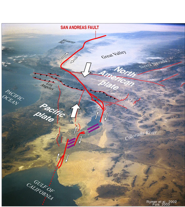
What is the San Andreas Fault? The San Andreas Fault is a transform fault, meaning that it is a geological feature where two tectonic plates slide past one another horizontally. It marks the boundary between two major tectonic plates—the Pacific Plate and the North American Plate. These plates are part of Earth’s lithosphere, and their movement is responsible for shaping much of California’s landscape. The fault is not just one continuous crack in the Earth’s crust but a complex network of fault zones, fault segments, and branches that extend over 800 miles (1,300 kilometers) through California.
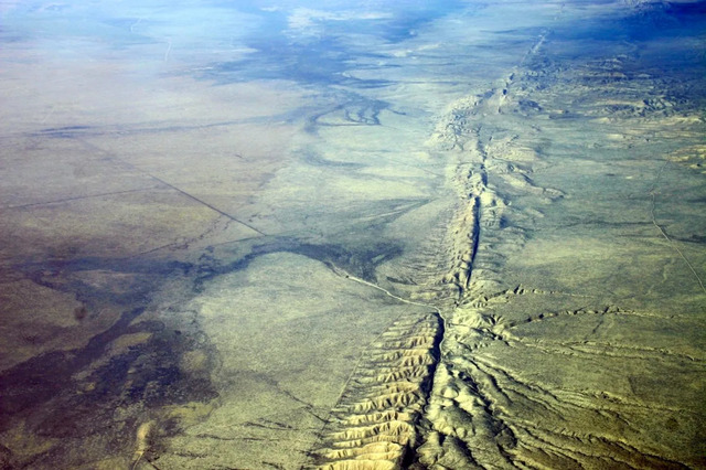
The San Andreas Fault begins near the Salton Sea in Southern California and extends all the way to Cape Mendocino in the north, passing through diverse terrains ranging from deserts to mountains and coastal regions. Its position makes it one of the most recognizable geological features in the United States, and it plays a crucial role in the seismic activity of California. As a result, it is closely monitored by geologists worldwide for its potential to generate massive earthquakes that could impact millions of people.
Video
Check out the video of flying a small airplane over the San Andreas Fault – it’s an exciting aerial view of this geological wonder!
Geological Significance of the San Andreas Fault
The San Andreas Fault is a prime example of a transform fault, where two plates grind against each other, resulting in lateral motion. The Pacific Plate moves in a north-west direction relative to the North American Plate, which leads to significant stress and strain along the fault. Over time, this movement causes both gradual and sudden shifts in the Earth’s surface. Transform faults are vital in the study of plate tectonics because they provide clear evidence of how Earth’s lithosphere behaves and how plates interact with each other.
The fault serves as the boundary where the Pacific Plate and the North American Plate meet, and the interaction between these plates shapes the geography of California. As the Pacific Plate moves northward, it slides past the North American Plate, causing the ground to shift and leading to the formation of unique geological features such as valleys, mountains, and fault scarps. These dynamic processes also make California one of the most seismically active regions in the world.
Historical Significance of the San Andreas Fault
Although the San Andreas Fault had been observed by various explorers and settlers, its true geological significance wasn’t fully realized until the early 20th century. The 1906 San Francisco earthquake, which was traced back to a rupture along the fault, played a crucial role in highlighting the fault’s importance to the scientific community. It marked a turning point in understanding the Earth’s seismic behavior and contributed to the development of the theory of plate tectonics, which revolutionized geology.
The San Andreas Fault’s existence provided tangible evidence supporting the theory of plate tectonics. Before its discovery, scientists were unsure of the mechanics behind earthquakes. However, the clear lateral motion of the plates along the San Andreas Fault demonstrated how Earth’s crust could shift and move over time. This breakthrough not only helped explain the origin of earthquakes but also provided the foundation for much of the modern understanding of Earth’s geology.
Notable Earthquakes and Impact
The 1906 San Francisco Earthquake

One of the most significant events in the history of the San Andreas Fault was the 1906 San Francisco earthquake. Measuring approximately 7.9 in magnitude, it caused widespread destruction in San Francisco and surrounding areas, leaving a profound impact on both the region and the scientific community. This earthquake, which resulted from a rupture along the fault, caused thousands of deaths and significantly reshaped California’s approach to earthquake preparedness and infrastructure development.
The 1857 Fort Tejon Earthquake
Another devastating event in the history of the fault was the 1857 Fort Tejon earthquake. Estimated at a magnitude of 7.9, it caused major surface ruptures and left a significant mark on the California landscape. This earthquake underscored the seismic hazards present along the San Andreas Fault, demonstrating that the region was prone to catastrophic events that could disrupt communities and infrastructure.
The 1989 Loma Prieta Earthquake
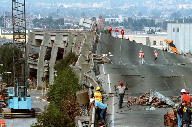
The 1989 Loma Prieta earthquake, measuring 6.9 in magnitude, is one of the most recent significant earthquakes to occur along the San Andreas Fault. It devastated the Bay Area, including San Francisco, and highlighted the vulnerability of large urban centers to earthquake activity. The earthquake reinforced the importance of seismic preparedness and brought about updates to building codes and infrastructure resilience.
The San Andreas Fault Today
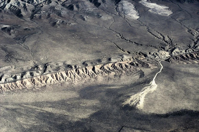
While large earthquakes along the fault have been relatively rare in recent decades, scientists continue to monitor the San Andreas Fault closely due to the potential for future seismic events. Recent studies suggest that the southern section of the fault, which hasn’t experienced a significant earthquake in over 300 years, is overdue for a major event. Research indicates that the stress accumulated along this section of the fault could lead to a substantial earthquake in the coming decades.
Given the fault’s importance, the San Andreas Fault is a primary subject of seismic research. Scientists use various methods, such as computer modeling and paleoseismic data, to better understand the fault’s behavior and predict future earthquakes. The California Geological Survey and other agencies continue to study the fault to improve early warning systems and prepare for possible seismic hazards.
The Southern Section of the San Andreas Fault
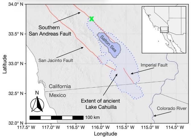
The southern section of the San Andreas Fault has been surprisingly quiet for over three centuries, despite historical data showing that it typically experiences a significant earthquake every 180 years. This period of inactivity has puzzled scientists, leading to various theories regarding its cause. One such theory suggests that changes in the water levels of the Salton Sea, located near the southern end of the fault, may be influencing the fault’s behavior.
The Salton Sea, a remnant of the much larger prehistoric Lake Cahuilla, has experienced fluctuating water levels over the years. Scientists have found that periods of high water levels correlate with increased seismic activity along the southern San Andreas Fault. This phenomenon occurs because large volumes of water can cause the Earth’s crust to bend, which can facilitate movement along the fault. Additionally, increased fluid pressure within the fault’s cracks may also make earthquakes more likely.
Geological Features Along the San Andreas Fault
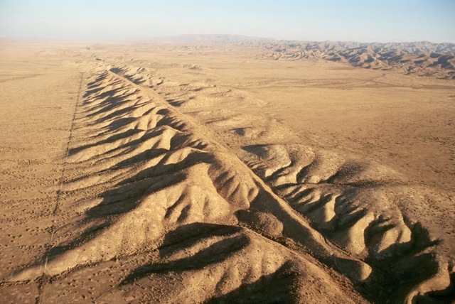
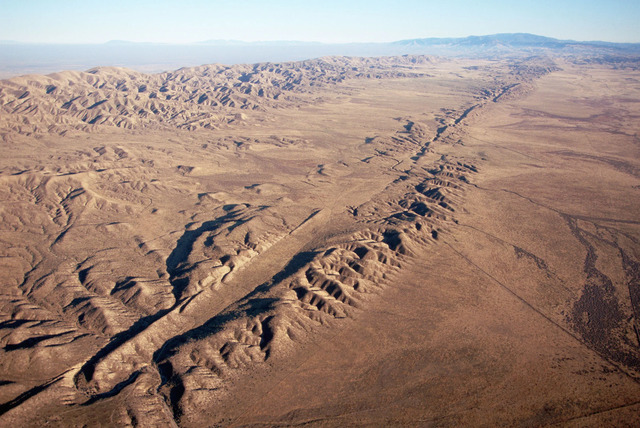
The San Andreas Fault has contributed to the creation of several striking geological features, such as valleys, fault scarps, and mountain ranges. The movement along the fault has shaped much of California’s landscape, including the Carrizo Plain, a vast expanse of flatland where the fault is visible at the surface. Other notable features, like the San Gabriel Mountains and the Tehachapi Mountains, have also been formed as a result of the fault’s activity.
The Carrizo Plain is a prime example of the fault’s impact on the landscape. It is home to the longest surface rupture associated with the San Andreas Fault, which stretches across the plain. The San Gabriel Mountains, located to the south of the fault, were also formed through tectonic activity caused by the San Andreas Fault. These features provide valuable insights into the ongoing movement of the Earth’s crust.
Seismic Hazard and Earthquake Preparedness
Given the frequent seismic activity in California, the San Andreas Fault poses a significant risk to both residents and infrastructure. Earthquakes along this fault can cause substantial damage, and as such, earthquake preparedness is crucial in the region. California has implemented stringent building codes and infrastructure development practices to reduce the impact of earthquakes, but the risk remains ever-present.
California’s building codes have evolved over the years to account for the risks posed by the San Andreas Fault. The state has made significant investments in ensuring that structures can withstand seismic activity, including retrofitting older buildings to meet modern standards. Efforts to strengthen infrastructure have focused on ensuring that critical facilities, such as hospitals and bridges, remain operational during and after an earthquake.
Educating the public about earthquake risks and preparedness is essential for minimizing casualties and damage in the event of a major earthquake. The state of California regularly conducts public outreach campaigns to promote earthquake preparedness, encouraging residents to secure their homes and create emergency plans for their families. Early warning systems and other technological advancements have also contributed to improving public safety.
Video
Watch the animated video to get a well-explained understanding of the San Andreas Fault – it’s an informative and easy-to-follow explanation!
Conclusion: The Future of the San Andreas Fault
The San Andreas Fault remains a dynamic and fascinating geological feature. Its potential to generate significant earthquakes makes it a focal point for scientific research, public policy, and earthquake preparedness. While California has made significant strides in mitigating the risks associated with the fault, the possibility of future seismic events cannot be ignored. Continued monitoring, research, and public education are critical to ensuring the safety of those living along the fault and to furthering our understanding of the Earth’s complex tectonic processes.
