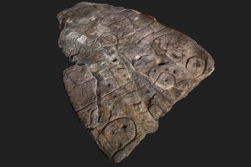
In the heart of France’s Finistère Department, a groundbreaking discovery has been made that promises to illuminate the ancient European landscape. The Saint-Bélec slab, a 4,000-year-old stone map, is believed to be Europe’s oldest cartographic artifact. This ancient relic, adorned with enigmatic markings, could potentially unveil a new chapter in the history of European archaeology. Discovered in 1900 and forgotten for nearly a century, the slab’s recent rediscovery and ongoing studies have sparked excitement among researchers, offering a tantalizing glimpse into the ancient world.
The Discovery of the Saint-Bélec Slab
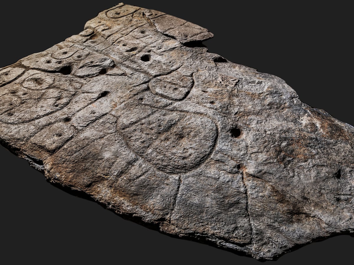
Unearthed in 1900 by French historian Paul du Châtellier, the Saint-Bélec slab was initially stored in du Châtellier’s home before being transferred to the French National Archaeological Museum. Despite its early discovery, the significance of the slab remained underappreciated until its rediscovery in 2014. The stone’s carvings, now recognized as the oldest known map of any European territory, depict the Odet valley during the Bronze Age, offering a unique window into the past.
The Stone’s Potential as a “Treasure Map”
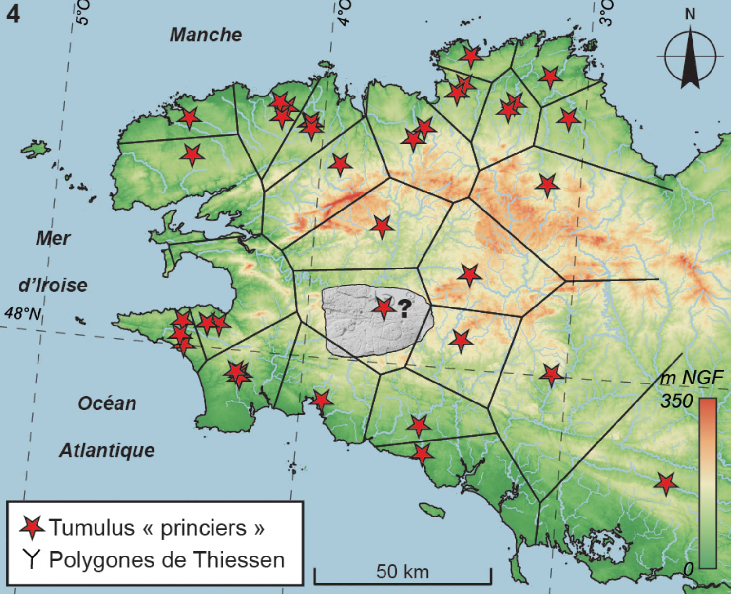
Professor Yvan Pailler from the University of Western Brittany, along with his team, proposes that the Saint-Bélec slab may serve as a literal treasure map. The stone’s intricate carvings could potentially guide archaeologists to undiscovered sites. With advancements in remote sensing technologies that complement traditional excavation methods, the slab’s detailed markings could lead to new archaeological findings, reshaping our understanding of ancient European landscapes.
Deciphering the Ancient Clues
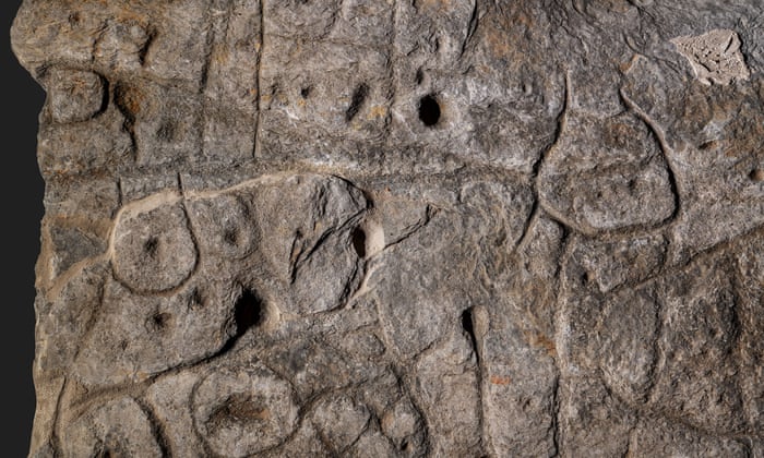
The Saint-Bélec slab features depictions of rivers, mountains, and other geographical features, with a high degree of accuracy compared to their modern counterparts. While some symbols remain ambiguous, researchers are hopeful that they may signify burial mounds or other significant archaeological sites. The process of decoding these markings is complex, with Pailler and colleague Clement Nicolas estimating that full decipherment may take over a decade.
Recent Excavations and Fragment Discoveries
Recent excavations at the original discovery site have yielded additional fragments of the Saint-Bélec slab. These fragments, which had been repurposed in the construction of a tomb wall, provide new insights into the stone’s context and the ancient landscape it represents. Ongoing research aims to piece together these fragments to enhance our understanding of the map’s historical significance.
Comparing Ancient Maps
The Saint-Bélec slab holds the title of Europe’s oldest known map, yet it is part of a broader tradition of ancient cartography. For example, the Imago Mundi, or the Babylonian Map of the World, dating back to the 5th century BC, is one of the oldest maps globally and is currently housed at the British Museum in London. These ancient maps provide valuable insights into early human understanding of geography and the world.
Conclusion
The Saint-Bélec slab, once overlooked and forgotten, has re-emerged as a pivotal artifact in the study of ancient European landscapes. With its intricate carvings potentially guiding researchers to undiscovered sites, the slab offers a compelling narrative of ancient cartography. As ongoing studies continue to decode its markings, the stone stands as a remarkable testament to the sophistication of early mapmaking and its role in unlocking the mysteries of our past.